


A topographic map of Riverside showing all the immediate prehistoric burial mounds. One exception is the Klamm mound that is off screen, upper right center.


The first professional to investigate and report on the Riverside burial mounds, was Elias Putnam West in 1877. West was an Independence lawyer who became a judge and eventually the attorney general for the state of New Mexico. He was also friends with Lykins. After West's 40 year legal career, he became interested in archaeology and paleontology. He was the founder of the Kansas City Academy of Science.
He would spend his later years at the University of Kansas under the direction of Professor Snow.
Upon his arrival in Riverside, he said in his report that there were 25 burial mounds, although he didn't document where they were.. He was a part of a new breed of investigators who had a goal of scientifically excavating the prehistoric mounds and recording that information for the future.
The people who investigated the mounds from 1878 to 1910, likely had the best intentions and unfortunately all we have today is what little they did write.
Being the first to scientifically see the mounds for the first time is important in today's world where modern archaeologists rely heavily on every written word in West's report.
Back during those times, investigating a mound was a Saturday afternoon thing. You arrive at the site, pull out a shovel and go straight for the heart of the mound for five or six hours. Later, when you get home, you write what you remember.
It is thought West excavated in the 5 mound group containing the largest mound and a second time in the Keller group nearest the Keller home. (The furthest east group of 3 on Keller land.)
West's full report appears below to his academy.


THE EUGENE KELLER HOUSE ABOUT 1910
W.H. R. Lykins, from the Smithsonian Institution, was part of West's team who returned. His findings were limited to three paragraphs in his paper; The Antiquities of Missouri, published in 1878. It is believed Lykins excavated the three mounds that were just west of today's intersection of Woodland and Valley.


Edwin Curtiss was a self-taught archaeologist and worked under the Peabody Museum. He excavated at the mounds in 1878 and we are not exactly sure which ones. Shippee believed it was within the group of 5 on the Platte-Clay border. He is literally best known for being a pot hunter for the Peabody Museum. Unfortunately, Mr. Curtiss passed away in 1880 at the age of 59.
Putnam (Curtiss), pg 718

Garland Carr Broadhead was a teacher, farmer, surveyor, engineer who was born in 1821 and studied at the University of Missouri. His career included stints as a design engineer for the railroad and was appointed by President Johnson to head Missouri's 5th district IRS.
Between 1874 and 1886, he found himself available to use his geology experience and at the age of 57 he spent one day investigating the mounds in 1878. He was accompanied by members from the Kansas City Science Academy and the Kansas State Science Academy.
Broadhead spend one day exploring the Brenner mound group. A disturbing fact is although Broadhead was excellent at details, he may had done more damage in one day in that he managed to somehow investigate four mounds in one day. These were the same mound group investigated by West and Lykins.
He noted seven mounds, three of which Lykins had investigated earlier. Of the seven, Broadhead and his team, investigated five of them – all in one afternoon. His report is the only one of the first three, to include a map and drawings of the vaults.
Broadhead's Drawing. Brenner Mounds 1-4 on left.
Broadhead, 1880 p350-52


No further professional investigations would take place for another 32 years. Then, in 1910, Gerald Fowke came to revisit some of the mounds to gather more information about the mounds themselves.
He was the perfect man for this because his critical analyses of several of his predecessors and contemporaries were at times definitely caustic, with the result that numerous controversies and near enmities resulted; however, in perspective, it cannot now be denied that the volume was both a contribution to archeological literature and a salutary influence in a comparatively young discipline.
Upon Fowke's arrival, he noted of West's observations of 25 mounds, there were now only 18. He said that 11 of the 18 were on Keller's property and the rest on Peter Brenner's. Today, with the aid of Shippee's sketches, we can account for 8 on Keller's and 14 on Brenner's. So there are at least three unaccounted for.
With an understanding of the critical nature of the man, one may read his report in a different way.
Fowke first came in 1907, then returned in 1910.
It's difficult to tell for sure, but it appears Fowke excavated everything West and Broadhead did and was particularly harsh when discussing Broadhead's work changing his mound numbering system.
Fowke was the only one who took photographs and they were of all four sides of at least three mounds. His photos show us how nicely the rock was laid and how square the rock vault walls were. Looking in the background of the pictures, we get the view of what the top of that ridge looked like.
Gerald Fowke

Fowke, 1910: p357

ONE OF FOWKE'S PHOTOS BELOW. COLORIZED BY BRENNER. THE REST OF HIS PHOTOS ARE AT THE BOTTOM OF THE PAGE. BRENNER MOUND, #2, SOUTH WALL


This is not one of the Riverside mounds, but based on the reports from West, Lykens, Curtis, Broadhead and Fowke, this is a very good representation of how one might have appeared in 1877.
Here is 2009 Google map of Riverside [Renner site in red circle] and the hand drawn map by
Shippee in 1947 which shows every known site at the time as well as the 20 prehistoric burial sites circled in red. The Shippee map is the only map I can find with all the mound locations.


From Shippee's 1940 Letter to Wedel


Waldo Wedel was from Nebraska and was the first to receive a PhD in anthropology with a heavy emphasis on archaeology, from the University of California, Berkley.
After one field season with the Nebraska State Historical Society, he went to work for the Smithsonian Institute. His first field assignment came after a letter was received from J. Mett Shippee. Shippee believed he had found a prehistoric village like no other west of St.Louis.
Wedel would go on to excavate at the Renner Site as well as other sites in and around the Kansas City area.
Wedel would stay his entire career with the Smithsonian and retired from there in 1976.
Through the 1980s and into the 90's, I did not know Dr. Wedel was still alive. Wedel passed in 1996. I can't believe I missed such an outstanding opportunity to at least talked to him by phone.
Everything I have read since his passing, had nothing but the highest praise for his work and as a highly regarded man.
T hrough his writings, I learned he didn't have a vary high tolerance for amateurs and “pot hunters”, particularly when they beat trained archaeologists to a site.
Early in his career, Wedel allowed some of those thoughts spill out when he was reviewing the first work of professionals at the Riverside mounds. These men had excavated 65 years earlier, spending not much more than an afternoon or two with their excavations.
Judge E. Putnam West was the first and he had speculated a large body of water had once filled the Line Creek Valley and even up to where the burial mounds were. (West; p15) Wedel (1943; p153) wrote, “That he erred in these particulars is not at all surprising if one bears in mind his evident lack of training and experience in the natural sciences as well as the general status of contemporary American archeology.”
Part of Judge West's argument was from the verbal communication from a local resident who said they found a stone ax three feet deep into the loess soil, which led to a lengthy writing by West of the large body of water and how these stone chambers could have been created far into prehistory. Wedel shot that down by saying, “Wholly untenable, of course, are his views as to the domiciliary function
of the chambers, and his assignment of an antiquity to be measured
in terms of millennia.
West was actually close to measuring the length of time for the deposit to occur. At that time, It had not been established the end of the last ice age had been 13,000 years ago. West had consulted a geologist about the length of time for the loess to accumulate. The geologist had told West that 20 feet of deposit would have taken 20,000 years, or about 24” every 2,000 years.
The reality was the accumulation of 120 feet over 13,000 years, with the bulk of that occurring during the first 4,000 years. Using a sliding scale where less loess was deposited as time went by, an artifact found 36”into the loess would be from about 1700 B.C. West's geologist's numbers would have been nearly the same.
There's little doubt that if there had been a large lake, it would have been before any human occupation. But,there actually is evidence there was one. We can see part of it where the Missouri River makes a hair-pin turn at the Broadway bridge. The earliest maps of Platte and Clay counties show parts of the old river bed turning well inside today's North Kansas City, before turning back again to it's current position. About six miles north of there, if you travel east or west on 152 highway between Green Hills road and North Oak, you can feel as many as 20 dips in the road. Some are worse than others. They are fault lines. That area is prone to tremors and the earth moves there. A couple of these fault lines extend south and at least one goes in a southwest to northwesterly direction.
One of these faults were active as recently as July, 2023.
Early settlers in the area, reported the Missouri River came out of it's banks every spring with some years being worse that others.
It's not at all out of the realm of possibility, since the end of the ice age, for either a combination of the fault lines or the floods, for the Missouri River to have developed a temporary damn near the North Kansas City area and causing the river to turn into a lake. This, or something similar, could have happened on a frequent or regular occurrence.
After the glacier maximum,the Missouri and Mississippi river levels would have flowed more than several times their size for quite a long time before settling down to their current state.
What we know today as the 500 year flood, was likely the norm until 8 or 9 thousand years ago. The glacier didn't just retreat one day. Over a period of a few thousand years, it would warm slightly and begin retreating for hundreds of years, only to come back with another cool down and reforming. There came a time when there were more warm days than cool and eventually the glacier went away.
In today's view of prehistoric man, 13,000 years ago is not “eons” in the past.
Wedel also put Broadhead in his place by expressing his opinion on Broadhead's numbering of the mounds and the way Broadhead worded that the bodies were found in a sitting position. Wedel was confused if we should take that literally or if these were simply bundles.
Wedel had criticism for each of the excavators on how faulty their work was in recording, where they were at and how they excavated. All the men,with the exception of Fowke.
None of these men knew that Mr. Pixley may have opened several, if not all the burials between 1872 and 1877, or perhaps the more modern Indians at the time from the plains who may have pillaged the mounds.
In Wedel's later life, he became an expert in prehistoric plains people and culture and drew some parallels to KC, mainly Steed-Kisker. (Wedel; 1943,p188) Wedel even found some comparisons to the Renner Site. (Wedel;1943, p194)
Wedel was an extremely detailed scientist, investigating every possible aspect of everything he would be researching.
Most of his premiere work is now nearly 88 years old and is still the pinnacle of measure archaeologists reference the most when it comes to the prehistory of our area.
I excavated at the Renner Site from 1980 to 1993 and I would have given just about anything to have spoken with the man had I known he was still with us. Most everything I had at that time about the Renner Site, were all written by Wedel or Shippee.
Today, even after 32 years of that fact, that's still about all I have regarding Kansas City archaeology.
TYPICAL OF THE UNIQUE RIVERSIDE VAULT CONSTRUCTION

RUDE KNOWLEDGE OF GEOMETRY, ALIGNMENT,LEVEL & PLUMB ARE JUST A FEW OF THE WORDS THAT COULD BE USED TO DESCRIBE THE BUILDING OF A STONE VAULT. IT WAS CLEARLY NOT SOMETHING ANY PARTICULAR PERSON COULD DO ON THEIR OWN AND WOULD HAVE TAKEN SOMEONE WITH YEARS OF EXPERIENCE AND SKILLED WITH LAYING AND HANDLING ROCK SLABS AS LARGE AS 250 LBS. IT WOULD HAVE TAKEN THE EQUIVALENT OF THE TOOLS LISTED BELOW.

Selected thoughts from West, Curtiss and Fowke.

Alana Holste [a facebook member] : Some groups of Native Americans have legends about a tribe of giants. Growth hormones can help decide the size of a person. As more research including investigating of burial sites around the world some of the myths are being found to be true rather than just myth. This is partially why, although part of me accepts, returning body parts to their original group's I also object to not doing more research on them before returning. Many of the parts now in various collections have only been listed in a catalog and not been looked at since they were donated often a century or more agoNew Paragraph
This is the number of skeletons, or pieces of skeletons, reported between the five individuals who excavated.
None of the mounds or vaults were totally excavated, except for those by Fowke. Broadhead reported seeing another floor and bones under a slab of rocks that they didn't excavate and nobody checked the perimeters where, in other regions, it was common to bury individuals outside of the vault area. None of the excavators dug deep enough in a mound or vault to determine where the deposits ended and virgin soil began.


Shippee 1920, 1934 and 37. Approximately 60 feet in diameter and about 6 feet tall, with notes revisited (1967:37). In a personal letter to Wedel (Nov 9, 1937), Shippee reported remains of at least 10 individuals and that the mound was never fully excavated.
Vault. No other information was found other than Shippee recorded it and had reported it in his 1937, November letter to Dr. Wedel (Nov 9, 1937). In that letter, he said, "It might be well to record here that it pointed back along the ridge to the north where there is some evidence of a cemetery."
I could find nothing on this except Shippee reported it on his 1940 survey. However Lykins, (1878, p 251) may have been referring to this as the vault overlooking the Line Creek on the east side. There is some evidence Broadhead (1878) may have excavated in 1878. [See article further below.]
Was a group of three vaults that were on the south ridge about 40 feet apart and together formed a triangle. Shippee recorded it and Broadhead mentions it in his 1880 papers (p352). I couldn't find any other information other than they were vaults.
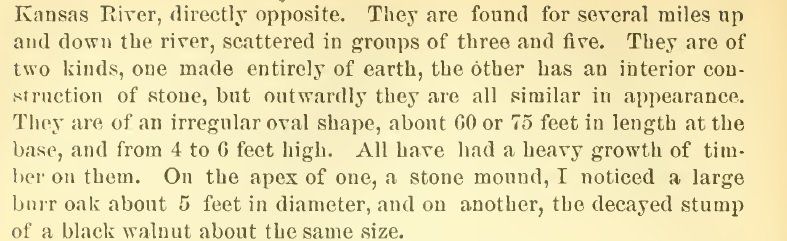
All except #4 were vaults where it was an earth mound. Mound #1 was recorded by West, 1877 (p16), Lykins, 1878 (p251), Broadhead 1880 (p352), Fowke 1910 (p70), Chapman 1947. [note: I could not find a report by Chapman, only notes made by Shippee that Chapman was there]. Stone lined vault with interior measurements of 7' 9" x 7" 9", with wall 36" tall with rock lined doorway to the south. Lykins did not recognize this as a vault, possibly because of West's work the year before.Mound #2. Broadhead, 1880 numbered this as mound #6. Fowke, 1910, numbered this as mound two as well as Lykins, 1878. . Same measurements and details as Brenner mound #1.Mound #3. Fowkes, 1910 (p70), Lykins, 1878 (p251). Same as Brenner vaults #1 and 2, except slightly larger and the doorway was facing east.Mound #4. Earth mound. Lykins, 1878 [refers to this as mound #1 in his report], Broadhead, 1880 and Fowkes 1910. This mound was 100 feet southeast of Brenner mound #2. Recorded as 50 feet in diameter and 5 feet tall.The other three were just east of the Brenner group and were stove vault mounds.
These were two large earth mounds only separated by 75 feet (Shippee, 1947). Both were recorded by Shippee (1940) to be oval-shaped at 65 x 30 feet in diameter and five feet high. Excavated by West, 1877, Lykins, 1878, Curtiss, 1879, Broadhead, 1880, Curtis and Putnam 1880 and Fowke, 1910. There was a lone vault mound just west of these two.
Were all stone lined burials consisting of eight vaults. West (1877), Fowkes (1910) and Shippee reported on these as well as Curtiss and Putnam 1879 by the Peabody Museum. Because of the lack of evidence, but easier access, it's likely everyone who has reported investigated these.


Below
1951, Looking west on West Platte towards the bluff where the Renner Mound was.

About the same view today.


Below is Keller vault 2, west view.

(below) Keller vault 1, west view.


A big question is if these people could construct these rock structures, then why didn't they build homes the same way or other rock structures here? We don't really know that these people didn't use these structures as homes, even briefly. None of the archaeologists reported digging down into clean subsoil. Most reported the lithic debris continued.

